destination guide
Omine-Okugake Trail
This World Heritage trail leads from the Yoshino and Omine mountains towards the Kumano Sanzan, three sacred shrines in Wakayama. A difficult trail, it serves as the training grounds for Shugendo practitioners. Although not recommended for inexperienced hikers, the sections around Yoshino and Tamakijinja Shrine are manageable, with spectacular views.
Starting in Yoshino, this ancient pilgrimage route traverses Nara's mountains and crosses over into Wakayama Prefecture, before reaching the three sacred shrines known as the Kumano Sanzan. The entire journey from Yoshino Station to Kumano Hongu Taisha, the nearest of the Kumano Sanzan, takes close to 100km and roughly 5 days to complete.
The section through Nara, from Yoshino to Tamakijinja Shrine, in Totsukawa, is approximately 75km. For a more manageable hike that can be completed in a day, consider following the route through the Yoshino mountains, and then hiking down to Dorogawa Onsen.
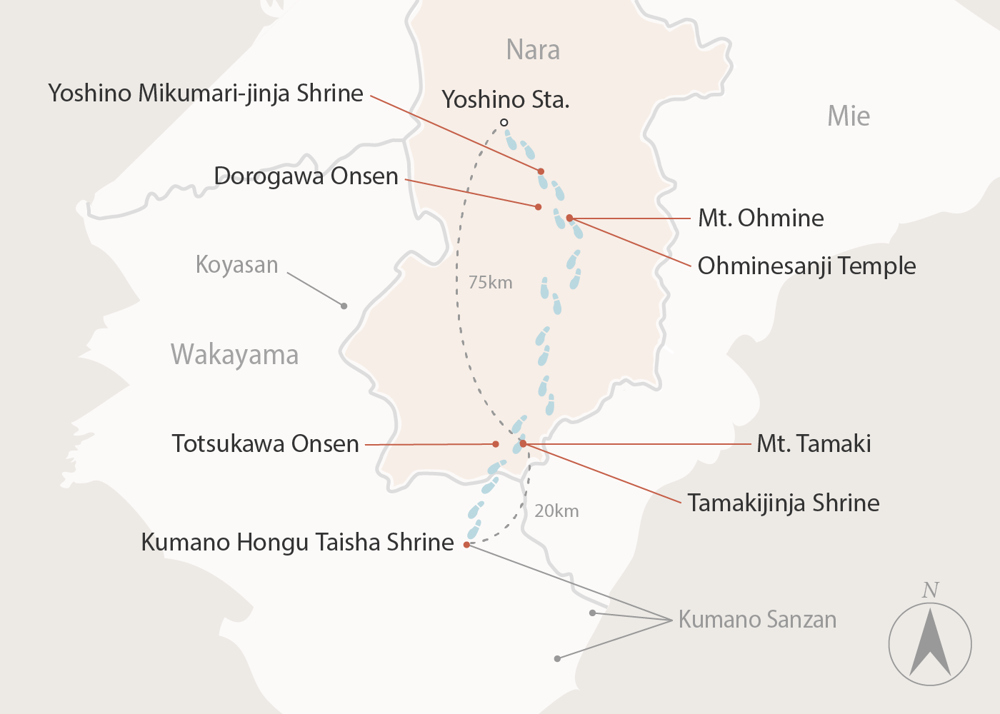
The first 10km of the trail from Yoshino Station leads through the Yoshinoyama area and passes various shrines and temples of interest. One of the first shrines you will come across is Yoshino Mikumari-jinja, dedicated to the deity of water. The inner courtyard has a beautiful weeping cherry tree.
A short walk from the shrine is Hanayagura Observatory, which has great views over the town of Yoshinoyama, especially in cherry blossom season, when thousands of cherry trees bloom across the area.
From Yoshino, the trail traverses several peaks, leading south in the direction of Totsukawa. Dorogawa Onsen, a traditional hot spring town at the foot of Mt. Omine, welcomes weary hikers to its soothing waters and traditional ryokan hotels. It is an ideal place for an overnight stay to break up the hike. Buses also run from here to Shimoichiguchi Station, for train connections back to Nara City and elsewhere.
From Dorogawa Onsen, you can hike up Mt. Omine to resume the trail and continue south. Considered sacred, the mountain is home to Ohminesanji Temple. Shugendo practitioners come from far and wide to make pilgrimages here during summer. The path up the mountain and the temple are off-limits to women.
Continuing on from Mt Omine and the Dorogawa Onsen region, the path takes you through Totsukawa, an enormous "village" that covers an area bigger than the metropolitan area of Tokyo.
Close to the border Totsukawa shares with Wakayama Prefecture, Mt. Tamaki stands at an altitude of over 1000 meters and is home to Tamakijinja Shrine. In a forest of ancient cedars shrouded in mist, the shrine feels far removed from modern life and has been a key stop on the Omine-Okugake Trail for over 1,000 years. Walk up from the shrine to the peak of Mt. Tamaki for sweeping vistas of the surrounding mountains.
From Mt. Tamaki, the trail continues on to the Kumano region in Wakayama. If determined to follow the trail to its end, make sure you are well-prepared and have sufficient supplies.
Getting There
Yoshino Station is the nearest station to Mt Yoshino which marks the start of the Omine-Okugake Trail. Taking a little over 90 minutes, the quickest route to Yoshino Station is from Kintetsu-Nara Station.

